Project: || Prior Study | Task 1 | Task 2 | Task 3 | Task 4 | Task 5 | Tasks 6-7 | Deliverables | Home
The Miasma Beach Transportation Model
PRIOR TRANSPORTATION MODEL APPLICATION IN MIASMA BEACH (2000)
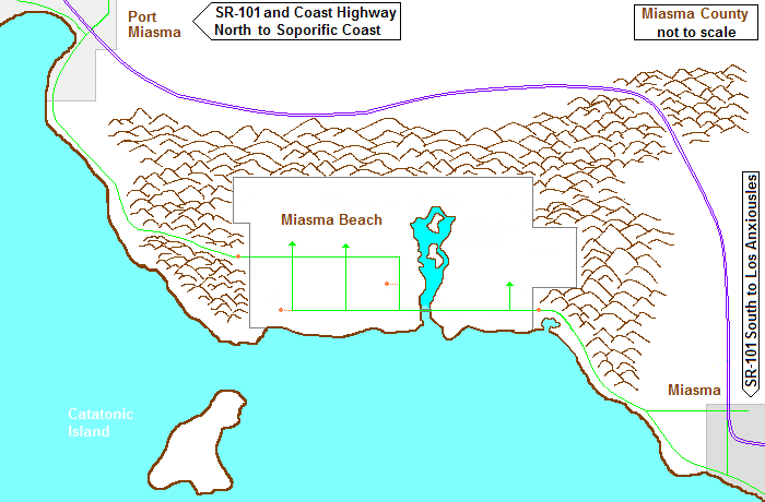
The County of Miasma is a coastal, agricultural-oriented, and primarily rural region that has just begun to see the impacts of increased land development and population growth as well as an influx of tourist traffic to and through the region. The major city and county seat is Miasma, located to the southeast closer to the rapidly growing neighboring county of Los Anxiousles. The coastal region north of Miasma comprises mountainous terrain linked by Pacific Coast Highway traversing the small city of Miasma Beach and proceeding north to Port Miasma, the second major city in Miasma County. The primary access route between north and south county is State Route 101, an inland freeway linking Miasma and Port Miasma, running north of the coastal Miasma Mountains that encircle Miasma Beach (see Figure 1).
Figure 1. Miasma Beach Region Alt F in 2000
2000 Miasma Beach Activity and Transportation Systems
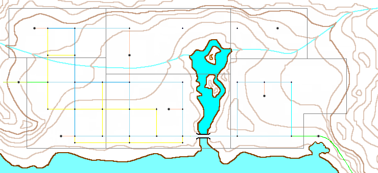
Miasma Beach is located on Miasma Bay within a seaside valley of approximately 14 square miles. The area, encircled by the Miasma Mountains, is predominantly low, flat, and fertile land, with the exception of residential areas in the foothills of Old Town and in the planned residential zones on the eastside. The Miasma Marsh wetlands consume 2 to 3 square miles in the central part of the basin. The southern border comprises wide beaches and an inlet to Miasma Marsh. The beach is bracketed by headlands to the west and the east. A topographic map of the study area is provided in Figure 2.
Zone 1 forms the Old Town Central Business District (CBD) and contain much of the total employment in the City. Zones 2 and 3 form a beachside community, a residential area with some retail activity along Coast Highway. Zone 4 is an agricultural area, with packing and processing industries, east of the CBD and north of Zone 3. Zones 5 and 6 are developing residential zones located east of the Miasma wetlands. Zone 6 is older and more developed than Zone 5, but has limited retail and other employment at this time. Similar to Zone 3, Zone 6 is oriented toward the beach. Zone 5 will begin development over the next few years. Zones 7 and 8 are External Stations: Zone 7 is at the eastern edge where Coast Highway heads toward the City of Miasma; Zone 8 is at western end of Miasma Blvd where SR-1 heads into the Miasma Mountains toward Port Miasma.
Figure 2. Topographic Map of Miasma Beach Area 2000
The 2000 transportation network (see Figure 3) is a partial grid of collector and local streets, with a single minor arterial, State Route 1, entering and exiting the City; within the City, SR-1 includes sections of Coast Highway, 3rd Street, and Miasma Boulevard). The six TAZ centroids are attached by single 0.25 mile centroid connectors. Facility characteristics are detailed in Table 1. Note that only selected links of local significance are coded in the 2000 network. There is no regular public transit service in the City.
Figure 3. 2000 Network Map of Miasma Beach Area
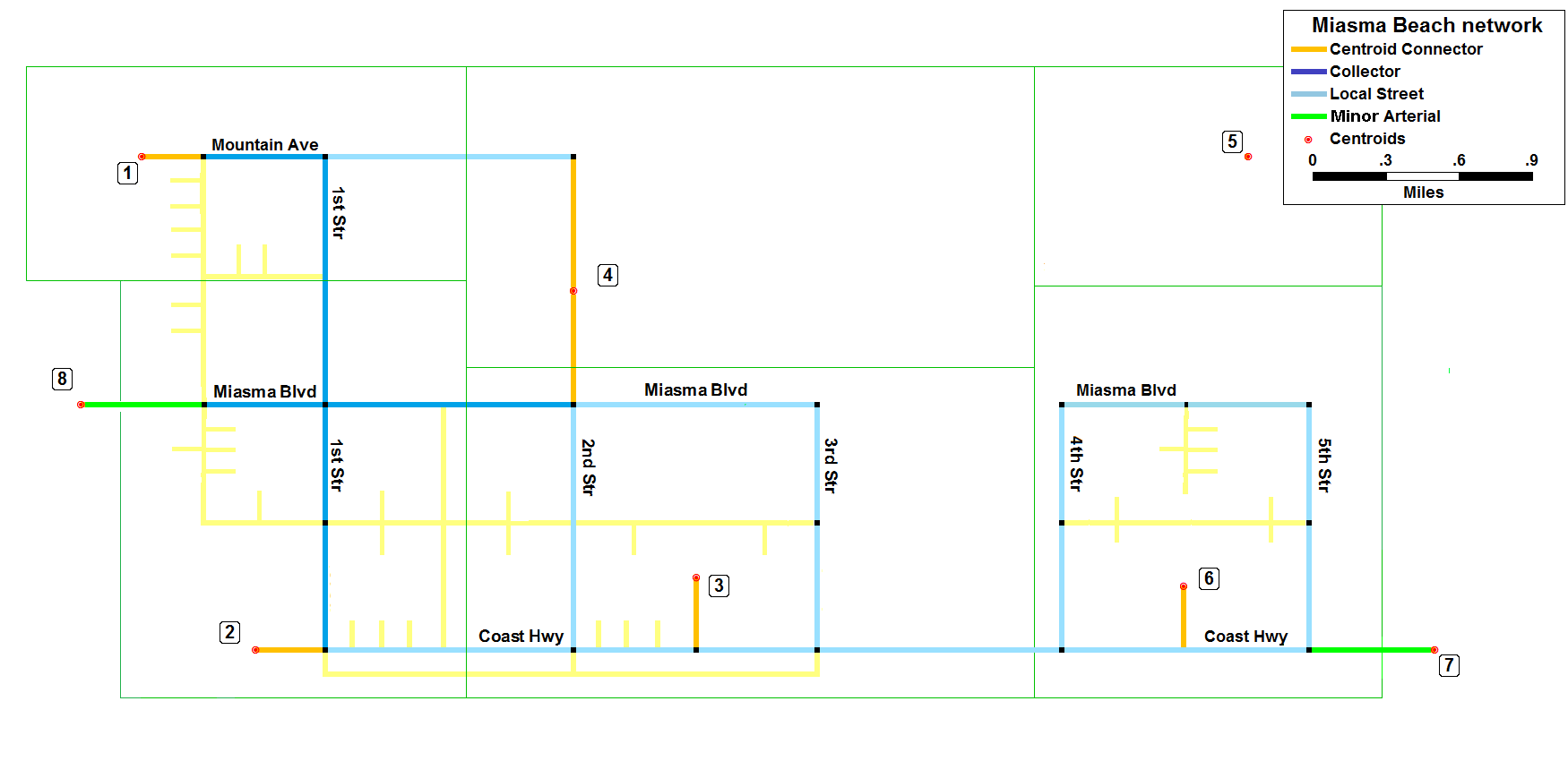
               Table 1. Miasma Beach Speed-Capacity Table
     ------------------------------------------------------------------
          Link Type          Speed   Lanes  Capacity/Lane   Color
     ------------------------------------------------------------------
      1.  Freeway              60      2        1800        Purple
      2.  Primary Arterial     60      2        1200        Red
      3.  Major Arterial       45      2         900        Dark Green
      4.  Minor Arterial       45      1         600        Lght Green
      5.  Collector Street     30      1         600        Blue
      6.  Local Street         15      1         300        Cyan
      7.  Other Street          -      -           -        Yellow
      8.  Ramp                 30      1         600        Pink
      9.  Centroid Connector   25      9        1000        Orange
     ------------------------------------------------------------------
The 2000 Transportation Study
Increasing growth both south of and within the County has begun to produce impacts on the local population, including increased congestion, diminished air quality, and traffic safety concerns. A major regional transportation study was launched in 2000 to examine the impacts of anticipated growth over the next decade. The City of Miasma Beach participated in a regional household travel survey that was used to develop a regional transportation model for Miasma County.
The Miasma Regional Travel Forecasting Model
The regional travel forecasting model developed is a conventional, TransCAD-based,
"Four Step Model" comprising the following steps:
- Transportation System: network coding was based on field studies and aerial photos
- Activity System: zone data from US Census and County Employment Surveys
- Trip Generation: production and attraction regression models for 3 purposes (HBW, HBO, and NHB)
- Minimum Paths: standard BPR link performance functions were used with free-flow travel times
- Trip Distribution: doubly-constrained gravity model with F-factors (no K-factors)
- Mode Choice: no mode choice model was estimated
- Time-of-Day: survey data to convert to O-D vehicle-trip format (for AM-, PM-, and Off-peak periods)
- Trip Assignment: highway assignment with equilibrium assignment
- Feedback: There is no currently feedback to prior steps in the current model system
- Air Quality: The regional is compliant, thus, no air quality modeling is required
Model Performance Output for 2020
The base model was validated using 2000 traffic counts. Modeled volumes on selected
screenlines and key links were within 5 percent of observed counts. Mean travel times
by trip purpose were within 10 percent of observed values.
The model was used to forecast 2020 traffic performance. Future demographic data required as input for trip generation was provided by the County Planning Office. The model projected significant flow increases within the Miasma Beach area. Based on estimated volumes and travel times, the County developed plans to upgrade State Route 1 from Miasma to Port Miasma to a Major Arterial. Based on planned internal growth, the City plans to upgrade most current streets and to build new facilities in Zones 4, 5, and 6. The following network changes were proposed for the next 10 years:
- Upgrade full length of State Route 1 to a Major Arterial (ES7 thru ES8)
(improvements include bike and pedestrian facilities and a new traffic control system) - Upgrade Coast Highway between 1st and 2nd Streets to a collector street.
- Add new section of 2nd Street between Miasma Blvd and Mountain Avenue as Local street; planned growth in Zone 4 will move centroid to now connect with 2nd street half way between Miasma and Mountain.
- Add new section of 4th Street between Miasma Blvd and Mountain Avenue as Local street.
- Developer will provide 0.5 mile local street extension of Mountain Avenue into Zone 5.
Future Plans 2020-2030
Based on observed and projected growth, the City of Miasma Beach decided to repeat the household travel survey in 2020 and also to develop a local travel forecasting model, based on and consistent with the Miasma Regional Travel Forecasting Model, but updating model components as needed. Given the cost of travel surveys, it is expected that a household sample large enough to update trip generation rates will be possible, but not a sample large enough to update the distribution model.